WASHINGTON, May 2, 2012- NOAA began using an updated weather forecast computer model this week to improve predictions of quickly developing severe weather events including thunderstorms, winter storms and aviation hazards such as clear air turbulence.
The Rapid Refresh (RAP) now provides NOAA's most rapidly updated weather forecast, replacing an older model that served a similar function. The Rapid Refresh, developed by NOAA's Earth System Research Laboratory in Boulder, Colo. and NOAA's National Centers for Environmental Prediction (NCEP) in Camp Springs, Md., updates every hour with a new forecast extending out 18 hours for North America.
The NOAA update on RAP notes that such forecasts are especially important in aviation, where fast-developing weather conditions can affect safety and efficiency, but are equally important for severe weather and energy-related forecasting.
"This new tool ensures that forecasts are the best they can be by using the latest science and computer techniques in an effort to create a more weather-ready nation," said NOAA National Weather Service’s National Centers for Environmental Prediction Director Louis Uccellini.
The United States is the only country in the world that updates computer model forecasts every hour using the latest observations from an extensive network of ground- and satellite-based sensors, radars and aircraft, stated lead developer of the new model and a research meteorologist at the Earth System Research Laboratory, Stan Benjamin, in the NOAA release.
NOAA ran the new model experimentally for 22 months at NOAA's NCEP. RAP will replace the older rapidly updated model, Rapid Update Cycle (RUC), which ran at similar frequency and resolution for an 18-hour forecast. However, in comparisons with the older model, the new Rapid Refresh (RAP) is more skillful, according to NOAA scientists.
"Overall, RAP provides equal or better forecasts than its predecessor for all variables, from winds to precipitation," Benjamin said.
For example, the new model performed significantly better than its predecessor in forecasting heavy rain that pounded the Midwest in June last year. For comparison, NOAA noted that the new forecasts more correctly projected the geographical areas that received 2 inches or more of precipitation.
According to NOAA, RAP's forecasts derive from three key improvements over the earlier model:

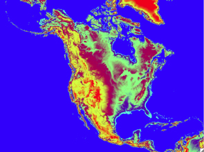
The Rapid Refresh model extends the geographical coverage of NOAA's weather situational awareness information to all of North America, not just the contiguous U.S. as was the case for the older model. (Credit: NOAA)
For more news, go to www.agri-pulse.com